Emergency managers in northern Wisconsin are trying to coordinate resources and confirm whether people are stranded by flooded roads as waters rise and recede from various areas after heavy rainfalls over the weekend.
In Douglas County, emergency management director Keith Kesler has been working with officials in Burnett County to provide services to people who could be impacted by the Radigan Flowage Dam that failed Monday afternoon.
“We both have people that we can’t provide emergency services to, so we were trying to make arrangements so some Douglas County stuff could slide south into Barron County if need be for fire and EMS,” Kesler said.
Stay informed on the latest news
Sign up for WPR’s email newsletter.
He said that includes efforts to place a helicopter in Siren, Wisconsin. Meanwhile, the St. Croix Bridge on Highway 77 at the Minnesota border is closed due to washouts. Kesler said water had reached the bottom of bridge.
“That’s where it was last night when we spoke about midnight, and it’s actually about the same level today,” he said. “We’re kind of hoping that the worst of the surge has went through.”
Crews were drilling holes through the road on the bridge into late Monday evening, according to Chris Cheney, District 1 Maintenance Superintendent with the Minnesota Department of Transportation.
“To relieve air that was being trapped under the deck so the deck wouldn’t be forced up and float from the rapidly rising water,” he said.
Duluth National Weather Service Meteorologist Joe Moore said flows on the St. Croix River do appear to be at their worst now with conditions improving in the next 36 hours. Crews with the U.S. Geological Survey measured the St. Croix River at 11.46 feet over State Highway 35 on Monday evening, setting a new record at that location.
A flood warning remains in effect through Thursday morning for western Burnett County.
Preliminary damage estimates are around $5 million in Douglas County, said County Board Chairman Mark Liebaert. However, he said it’s likely that figure could grow.

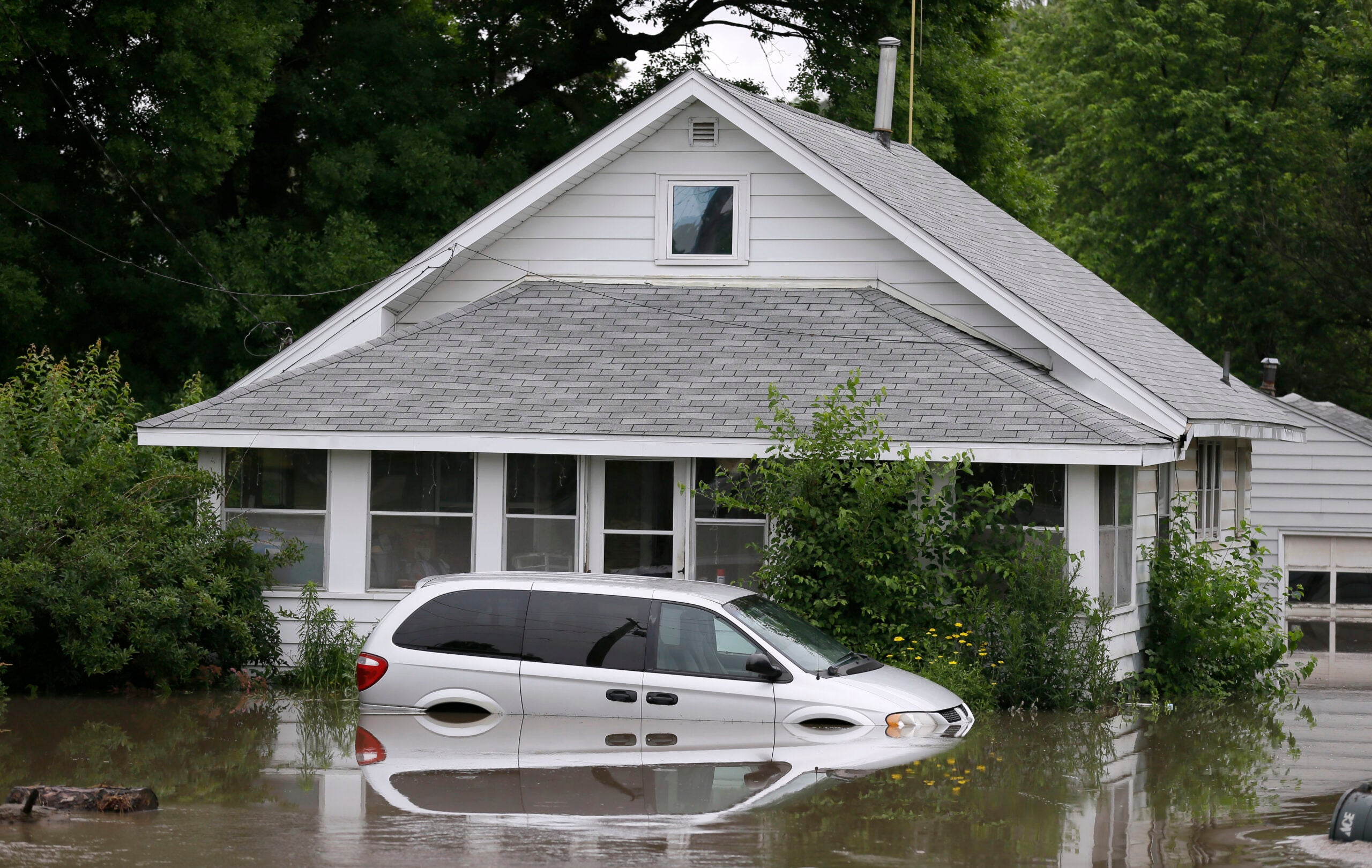
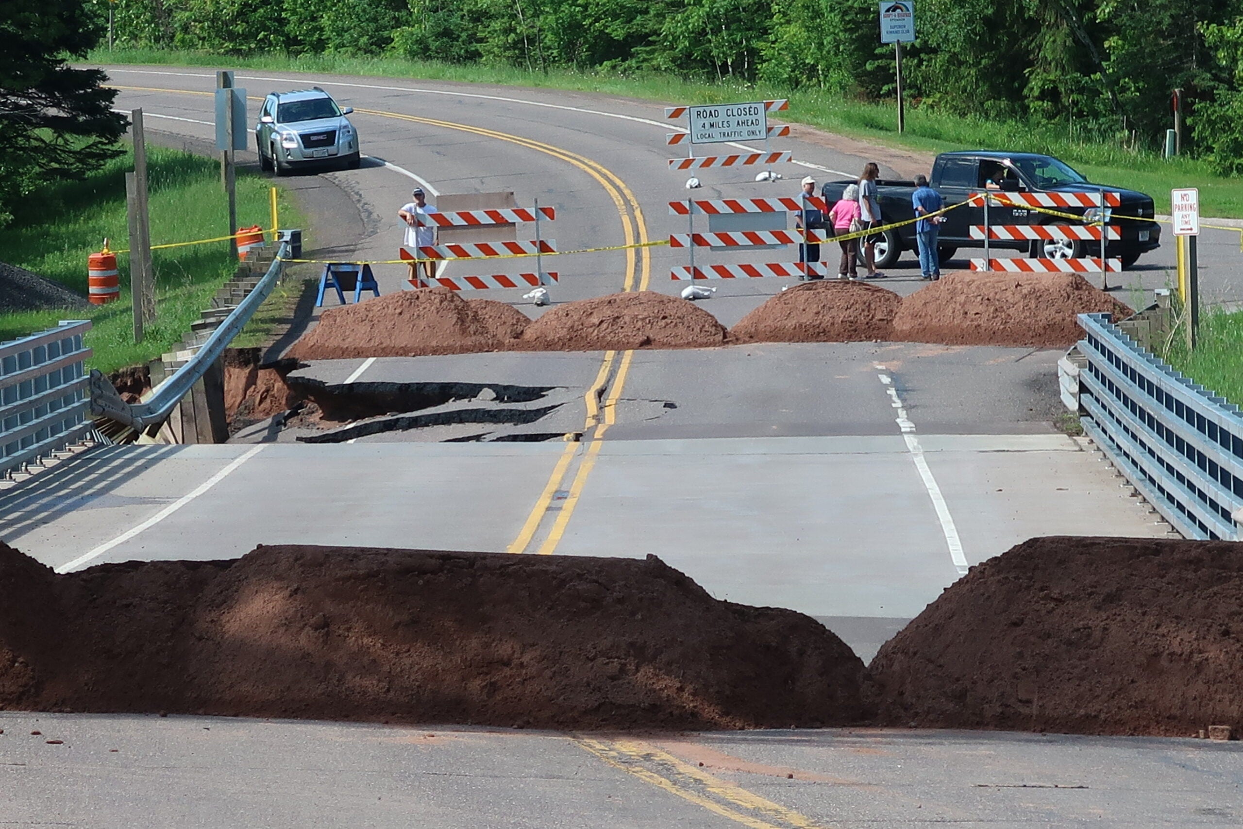
Roads closed in Superior, Wisconsin due to flooding after heavy rainfall. Danielle Kaeding/WPR
“Because some of the townships haven’t done assessments. One of the ones that was very heavily hit is Dairyland. I think they’re the highest estimate at $1 million,” he said. “But, they just had a dam that partially let loose. If you include the replacement or the damage that dam could do, we could have a lot more dollars even from Dairyland.”
The Cranberry Creek Flowage Dam near Solon Springs also failed on Tuesday. Liebaert said he hasn’t heard whether impacts rise to the level of a 100-year-flood, but, if so, it would be the third such incident in the last decade.
“Maybe we’re going to have to learn some more techniques to handle these longer floods because it looks like we’re going to deal with them more often,” he said.
Moore with NWS said initial estimates indicate that parts of northwestern Wisconsin experienced more than a 100-year flood event. He based that on comparisons of rainfall estimates and precipitation archives from NOAA Atlas 14.
“Not everywhere in Wisconsin saw that kind of severity, but definitely parts of northwest Wisconsin, particularly Douglas and Bayfield Counties,” he said.
Reports of 15 inches of rain from Drummond in Bayfield County may go on the record as a 1,000-year rainfall, Moore said.
Areas of Douglas County near Pattison State Park down to the Black River remained fairly inaccessible on Tuesday. Although, Kesler said Minnesota had reopened Highway 8, providing a path for people to circumvent flooding on the Minnesota side.
The damage in Douglas County appears to be greater than what was witnessed during the floods of 2012 and 2016. Kesler said they don’t have the volume of homes that were affected in 2012. Around 35 people had reported flood impacts to crawl spaces, basements, driveways and homes on Tuesday.
Flooding has impacted seasonal residences, and the county is still gauging impacts to public infrastructure, but it is not including impacts to major highways in its damage assessments.
“You can’t count numbers like what it’s going to cost to repair Highway 2 or Highway 53 because those are state and federal highways,” he said. “You can only count town and county roads, town and county buildings, parks, things like that.”
In Bayfield County, emergency management director Jan Victorson said they’re trying to confirm reports people may be landlocked while towns continue to close roads. County Road G is being used as a detour around a massive washout on U.S. Highway 2. However, she said they’re discouraging truck traffic on the road at this time.
“Light traffic should not be a problem, but however we’re really discouraging truck traffic from being on that road,” Victorson said. “We’re really concerned that it will destroy the road with the undermining that’s already occurred. We’re asking truck drivers to stay off County Highway G. Continue to use Highway 13 as their route of travel.”
Damage at U.S. Highway 2 could take months to repair. She added that a number of roads in the Chequamegon-Nicolet National Forest have been damaged, and the U.S. Forest Service is working closely with towns to resolve any issues. Around 60 miles of forest roads have been damaged by weekend storms, according to a release from the U.S. Forest Service.
Victorson said flooding hit some of the same areas in the county during July 2016, while others remain unaffected. A couple towns are reporting preliminary damage estimates of more than $100,000.
“One of the wonderful things is we have seen some areas that were mitigated or repaired after the 2016 flood that have held up well,” she said.
Water is receding in some portions of the county, while 3 feet of water remains on roads in some areas. U.S. Highway 63 remains closed. Meanwhile, flows on the Bad River near Odanah have gone down. The river is not expected to cause any closures of U.S. Highway 2.
After the rainfalls, Gov. Scott Walker declared a state of emergency in Ashland, Bayfield, Burnett, Douglas, and Iron counties Monday evening.
Wisconsin Public Radio, © Copyright 2024, Board of Regents of the University of Wisconsin System and Wisconsin Educational Communications Board.